Hurricane Polo a very powerful Category 4 storm off Mexico. See its path.
Hurricane Polo rapidly intensified off the coast of southwestern Mexico on Tuesday, growing into a powerful Category 5 storm that could bring life-threatening flooding to parts of the states of Guerrero and Michoacán, the National Hurricane Center said.
Polo reached Category 5 strength Tuesday morning after its maximum sustained winds had risen from 150 mph to 160 mph. It may continue to strengthen somewhat through Wednesday, according to the hurricane center.
At 6 a.m., Polo was about 220 miles south of Zihuatanejo, a coastal resort city in the state of Guerrero, and about 360 miles south-southeast of Manzanillo, another coastal city and resort destination in the state of Colima. It was traveling eastward near the Pacific Coast of Mexico at 6 mph, according to the hurricane center.
The hurricane center said that "rainfall may produce life-threatening flooding and mudslides, especially in areas of steep terrain."
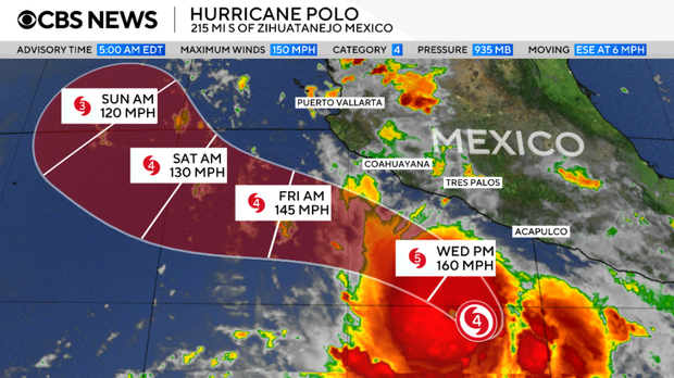
A tropical storm watch was in effect for a stretch of the Mexican coast, from Tecpan de Galeana, in Guerrero, to Manzanillo. The hurricane center issues tropical storm watches when meteorologists forecast possible tropical storm conditions within the watch area, usually at some point in the next 48 hours.
Forecasters said they expect Polo to continue on its current path before making a sharp turn toward the northwest Tuesday night and Wednesday, bringing the core of the hurricane near the southwestern Mexican coast in the coming days. As of early Tuesday, the storm was forecast to remain offshore, but it would likely bring heavy rainfall, in addition to what the hurricane center described as "life-threatening flooding and mudslides" to some coastal places, especially those located in steep terrain.
Parts of Guerrero and Michoacán may receive between 4 and 8 inches of rainfall as Polo barrels past, with up to 12 inches possible in certain spots, through Thursday. Between 3 and 6 inches of rain could also fall in coastal parts of the states of Oaxaca, Colima, and Jalisco through Thursday, forecasters said.
In:
KioskNews shows a cleaned-up reading view extracted from the publisher’s page — the original always lives on their site, not ours.