Southwest residents on alert as ‘dangerous’ Hurricane Polo moves up Mexico’s Pacific coast
Residents of the states of Guerrero and Michoacán remain on alert Tuesday as Hurricane Polo, a Category 5 hurricane, moves slowly along the Pacific coast and is forecast to bring heavy rain to southwestern Mexico.
At 9 a.m. Tuesday, the U.S. National Hurricane Center described Polo as ‘extremely dangerous’ with maximum sustained winds of 165 mph (270 km/h). It was moving slowly north at 2 mph, located about 200 miles (330 kilometers) south of Zihuatanejo, Guerrero.
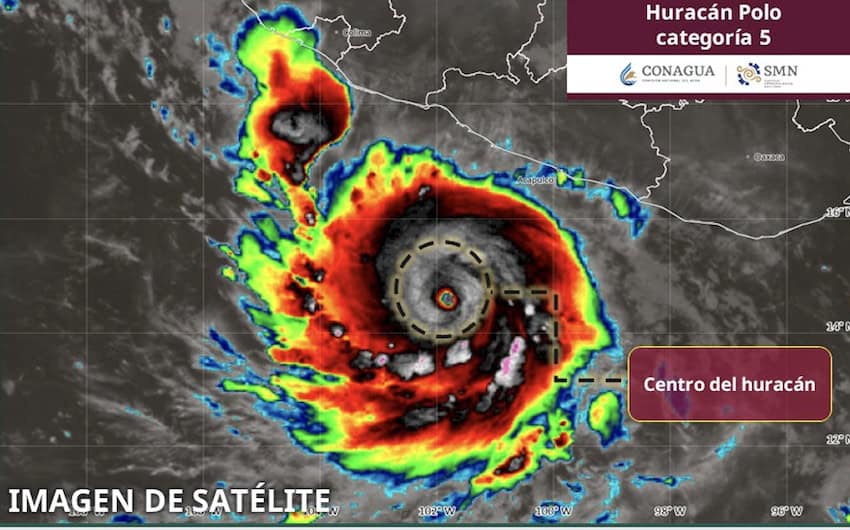
Hurricane-force winds extend outward up to 35 miles (55 km) from the center and tropical storm-force winds extend outward up to 90 miles (150 km).
The storm had been moving east slowly toward the coast, but had begun to turn northwest and is forecast to continue west-northwest, moving away from land by Wednesday night.

Maximum sustained winds have increased to near 165 mph (270 km/h) with gusts reaching 195 mph (315 km/h). Additional strengthening is likely through Tuesday, with fluctuations possible throughout Wednesday.
Authorities have suspended classes in Guerrero and Michoacán and schools will remain closed through Wednesday. The Navy has restricted navigation in several ports as authorities continue to monitor the storm’s development.
Polo is expected to dump up to 6 inches of rain across coastal portions of Guerrero and Michoacán through Thursday. The National Water Commission has warned of potential landslides, overflowing rivers and streams, flooding and waves of up to 4 meters (13 feet) in Michoacán and Guerrero.

Rainfall of 2 to 4 inches is possible in coastal portions of Oaxaca, Colima and Jalisco through Thursday.

A Tropical Storm Warning is in effect for the Pacific coast from Tecpan de Galeana, Guerrero, north to Punta San Telmo, Michoacán. At the same time, the Tropical Storm Watch that has been in effect north of Michoacán was extended westward to Playa Perula, Jalisco.
A Tropical Storm Warning signifies that tropical storm conditions are expected within 36 hours, whereas a Tropical Storm Watch means that tropical storm conditions are possible within 48 hours.
The governments of Michoacán and Guerrero have issued warnings encouraging residents — especially those living near the coast — to adhere to recommendations by Civil Protection authorities and take precautions to secure their homes against heavy winds.
Guerrero has established a Civil Protection center in Zihuatanejo to coordinate emergency response and mitigate risks.
With reports from El País, The Associated Press and NBC News
KioskNews shows a cleaned-up reading view extracted from the publisher’s page — the original always lives on their site, not ours.