וואלההוגש כתב אישום נגד תושב בית שמש שניסה לרצוח את בן זוגה של גרושתוBollywood HungamaEXCLUSIVE: Ajay Devgn-Rohit Jugraj’s horror thriller titled SuryasparshThe Jerusalem Post'No cure for stupidity': Israel's Football Association blasts Irish coach's calls to boycott matchRTP DesportoCorridas de Fórmula 1 mais curtas a partir de 2027PunchVIDEO: NSCDC busts illegal fruit juice factory in Lagos, arrests twoInquirerPalace on transport strike, fuel price increase: Fare hike is not the solutionSouth China Morning PostWere the Serbian military’s new robot dogs built using Chinese technology?Collider‘Stranger Things’ Has Officially Lost Its Streaming EdgeMalay MailDo not usurp the constitutional function of the DKU — Hafiz HassanThe RegisterLongtime SUSE staff asked if they'd opt for 'voluntary separation'Daily MaverickWHAT’S COOKING: A pair of meaty recipes to plan for Braai DayCBS NewsIran's president heads for U.N. summit ahead of possible Trump meeting
The Daily Newsstand · Free, Always
Tuesday, September 22, 2026

LPA outside PAR has high chance to become tropical depression
Translate
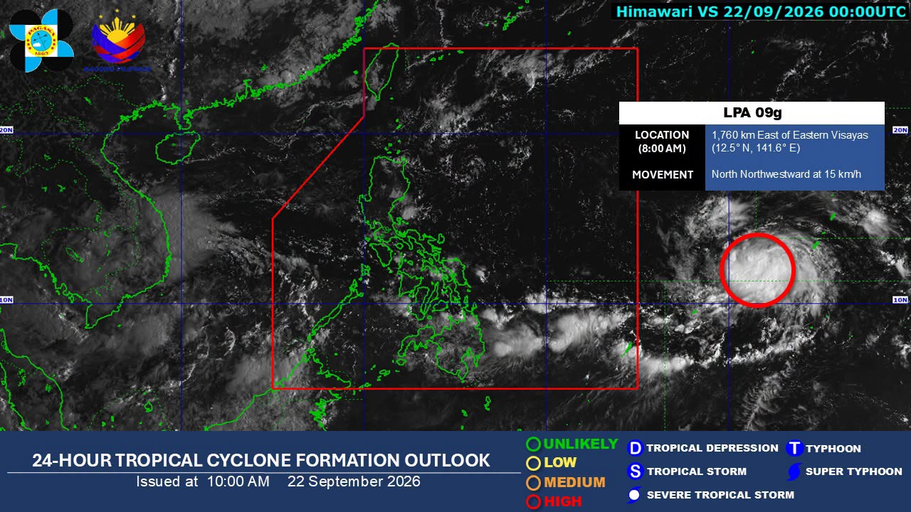
24-hour tropical cyclone formation outlook issued by Pagasa at 10 a.m. on September 22, 2026. (Photo by Pagasa/Facebook)

MANILA, Philippines – The low pressure area (LPA) outside the Philippine area of responsibility (PAR) has a “high chance” of developing into a tropical depression within the next 24 hours, the state weather bureau said on Tuesday.

READ: Trough of LPA outside PAR to affect parts of Visayas, Mindanao Tuesday

This is based as of 8 a.m. on the 24-hour tropical cyclone formation outlook issued by the Philippine Atmospheric, Geophysical, and Astronomical Services Administration (Pagasa) issued at 10 a.m. 

Article continues after this advertisement

The LPA was last estimated 1,760 kilometers east of Eastern Visayas, moving north-northwest at 15 kilometers per hour. 

FEATURED STORIES

NEWSINFO

NEWSINFO

NEWSINFO

In its separate 5 a.m. weather forecast, Pagasa said that the LPA may enter the PAR in the coming days.

Once it becomes a tropical depression inside the country, it will be given its local name Queenie.  /gsg

View the original on Inquirer

KioskNews shows a cleaned-up reading view extracted from the publisher’s page — the original always lives on their site, not ours.