ITCZ affects parts of Philippines; Typhoon Queenie exits PAR

Already have Rappler+?
to listen to groundbreaking journalism.
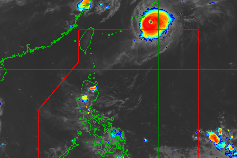
QUEENIE. Satellite image of Typhoon Queenie (Surigae) outside the Philippine Area of Responsibility as of September 27, 2026, 8 pm.
PAGASA
The Visayas, Zamboanga Peninsula, Northern Mindanao, Caraga, Lanao del Sur, and Basilan have scattered rain and thunderstorms due to the intertropical convergence zone
MANILA, Philippines – Rain from the intertropical convergence zone (ITCZ) will persist in the Visayas, Mindanao, and Palawan in the next 24 hours, the weather bureau said on Sunday afternoon, September 27.
The ITCZ is a belt near the equator where the trade winds of the Northern Hemisphere and the Southern Hemisphere meet.
It is causing scattered rain and thunderstorms in the Visayas, Zamboanga Peninsula, Northern Mindanao, Caraga, Lanao del Sur, and Basilan, as well as isolated rain showers or thunderstorms in the rest of Mindanao and Palawan.
The Philippine Atmospheric, Geophysical, and Astronomical Services Administration (PAGASA) said flash floods and landslides are possible.
The rest of Luzon will continue to have generally fair weather, with just localized thunderstorms.
Meanwhile, Typhoon Queenie (Surigae), which did not affect the country, left the Philippine Area of Responsibility (PAR) at 11 am on Sunday.
As of 8 pm, Queenie was already 935 kilometers northeast of extreme Northern Luzon, moving east northeast at 20 kilometers per hour (km/h).
The typhoon’s maximum sustained winds have since reached 175 km/h, with gustiness of up to 215 km/h. Around the time of its exit from PAR, its maximum sustained winds were at 150 km/h.
Queenie entered PAR as a tropical storm last Thursday, September 24, and remained far from Philippine landmass. It intensified into a severe tropical storm on Friday, September 25, and into a typhoon on Saturday, September 26.
Queenie was the Philippines’ 17th tropical cyclone for 2026, and the first for September. As of Sunday evening, no new low pressure areas or potential tropical cyclones are being monitored inside or outside PAR.
For October, November, and December, PAGASA predicted that there could be one or two tropical cyclones per month. The next six local names are Rosal, Samuel, Tomas, Umberto, Venus, and Waldo. – Rappler.com
KioskNews shows a cleaned-up reading view extracted from the publisher’s page — the original always lives on their site, not ours.