A tale of twin cities: How digital replicas could help transform urban governance
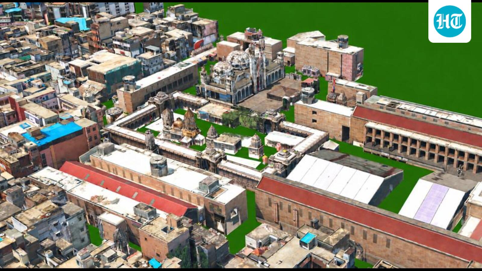
One is the ancient city of temples, ghats and crowded, labyrinthine lanes along the Ganga. The other is its digital twin — a 160-sq-km digital replica built from LiDAR, aerial and drone imagery and 360-degree street-level scans, captured using light aircraft, backpack-mounted scanners and vehicles. It’s a digital representation of the city, linked to real-world data and capable of being updated, analysed and used to simulate scenarios.
The ancient city is already putting new-age technology to work.
“Digital Twin has enabled us to identify areas likely to be hit by rising water levels, spot potential waterlogging zones, and flag houses that could be affected by floods, allowing officials to plan relief and rescue operations, and position resources, before the water rises,” says Santosh Tripathy, GIS project manager, Varanasi Smart City.
“And it’s not only about floods. We’ve done impact analysis for roads being widened across the city, including Dal Mandi. We could tell the PWD in advance how much built-up area would need to be demolished and exactly which properties would be affected,” he adds. “The digital twin also helps us spot encroachments, and when we compare the new 3D data against our older records, it shows buildings that were residential a few years ago and are now running as hotels or commercial spaces, which means the property tax can be revised accordingly. We believe revised assessments could raise municipal property tax collections by as much as 50 per cent.”
Varanasi isn’t alone. Mumbai, Kochi, Kanpur, Pune and other cities are building their own digital twins using high-precision 3D mapping for planning, infrastructure management, redevelopment and disaster response. In Mumbai, a detailed digital twin of Dharavi has been built as part of the area’s redevelopment, meant to serve as a spatial baseline for rehabilitation.
“Conventional two-dimensional maps record where assets sit. A spatial digital twin holds the city as it stands and registers it as it changes,” says Sajid Malik, chairman and managing director of Genesys International, the company behind both the Varanasi and Dharavi projects.
Dharavi is one of the world’s most complex urban redevelopment exercises — homes, workshops, commercial spaces, lanes and utilities layered over decades, in extraordinary density. Before redevelopment can begin, planners face a basic question: what exactly exists, and where?
Genesys’s mapping there combines LiDAR, drone capture and ground surveys, documenting structures, lanes, utilities and tenement details. “It also creates an evidentiary baseline,” Malik says. “What was measured, where it stood and who occupied it are recorded once and referenced across the redevelopment lifecycle, bringing transparency to the process and narrowing the ground for disputed claims,” he adds.
Genesys has signed an MoU with the Survey of India to build digital twins of major Indian cities, in line with the National Geospatial Policy, notified in 2022, which envisages a National Digital Twin for major urban centres by 2035. Genesys is currently working on digital twins for several cities, including Kochi, Kanpur and Pune, which are at different stages of development.
While these are still early applications, they come at a time when Indian cities face mounting pressures: informal settlements, large-scale redevelopment, heritage protection, flooding and infrastructure strain, all demanding a far more precise picture of what’s actually on the ground.
A governance or information revolution?
“The most important part of a digital twin is the ability to show where a city is lying to itself,” says Vivek Agarwal, country director-India at the Tony Blair Institute, which has advised state governments in India on education and digital governance reforms.
Indian urban governance, he says, functions on a fantasy: that the master plan on paper represents where people actually live. It rarely does. Two-thirds of India’s urban settlements don’t even have a master plan, he points out, and the ones that do are reviewed only once every several decades. A digital twin fills that gap between paper and pavement — surfacing unassessed floors, encroached plots, lanes that flood every monsoon without fail.
“But I’d be reluctant to call this a revolution in governance. It is a revolution in information,” he says. Digital twins show officials the gaps in their own infrastructure, but finding a problem and fixing it are different things. Bengaluru made digital property maps over a decade ago, he notes, and very little changed, because officials simply kept doing things the old way. “ Digital twins don’t solve Indian urban governance — they take away urban planners’ biggest excuse, that no one knew what was going on. After that, governance depends on institutions, incentives and political will, all of which are outside the realm of digital twins.”
What India can learn from global cities
Singapore has been building Virtual Singapore, a data-rich 3D model that lets planners test interventions before they happen, modelling their effect on traffic, population and environmental conditions. The lesson: officials can ask “what if” before anything changes in the real city.
Helsinki offers a different lesson. Its Kalasatama digital twin runs on a simple principle: design, test and build digitally first, and the city has opened the model up for public engagement, letting residents experience planned developments virtually before they’re built.
Agarwal sees a flaw in the Indian approach by comparison: “In India, every deployment so far has been top-down : built by vendors, for the authorities, with residents as subjects of the survey, not participants.”
The UK’s National Digital Twin Programme offers a third lesson: digital twins need shared standards, interoperability, clear governance and long-term maintenance. Built around the UK’s Gemini Principles, it allows different organisations to build and manage their own models while sharing data safely.
These cities don’t treat digital twins as one-off mapping projects. They build the institutions, standards and systems needed to keep them useful.
Conservation architect Shikha Jain has used LiDAR and photogrammetry in heritage projects for years, documenting Udaipur’s City Palace facade from a moving boat where manual measurement was impossible, and capturing temples with intricate architectural detail. Narrow lanes and crowded haveli facades, she says, mean the work has to happen at dawn, before streets fill with people, vehicles and autos that block the view.
But Jain also reminds what goes wrong when technology is mistaken for capacity. “These tools are extremely useful if we can manage real-time, live monitoring of our cities through them,” she says. “The problem is most urban local bodies lack the software infrastructure to handle the datasets these tools generate, and officials still need training to actually use them.”
Who owns the model?
Anup Jindal, CEO, RMSI, a Noida-based geospatial technology firm that has worked with governments and cities worldwide, talks about a more structural problem: Indian cities are divided among multiple agencies, all keeping their own, often conflicting, datasets. “Cities need common standards for their data, and an apex city-level agency with the statutory authority to develop, operate and maintain the digital twin,” he says.
Jindal says India’s immediate challenge is one of survivability rather than sustainability: “India’s rapidly growing cities are dealing with severe flooding, traffic congestion, housing shortages and infrastructure stress. Two hours of rainfall can halt an entire city.” His advice: a digital twin doesn’t need to be a monolith. Cities should adopt a phased rollout, starting with high-impact applications like flood management, property tax mapping and traffic flow.”Departments miss thousands of built-up square feet hidden behind upper-storey extensions. A detailed 3D model, repeatedly updated through aerial surveys, can make that visible.”
The significance goes beyond recovering revenue, he says. It’s about replacing an inspection system that depends on physical visits with one where change is detected systematically. Traffic management, he adds, is another obvious use case, and one that doesn’t require an entire city to be mapped and connected first.
Jindal’s larger point is that planning must become dynamic, with digital twins allowing cities to test different futures—from heavier rainfall and rising temperatures to population growth and changing transport demand—rather than trying to predict what a city will look like decades from now.
The umpire’s call
Agarwal is more cautious about how far digital twins can take Indian cities without institutional change. Invoking cricket’s Hawk-Eye, he says the technology became more useful when it acknowledged uncertainty through the “umpire’s call”. For digital twins, he argues, the equivalent is an institutional system that can question the model when it matters.
He points to what’s missing: ownership and interoperability, budget and data protection. “PM Gati Shakti has shown dozens of ministries can be brought onto a shared map when there’s political will, but there’s no comparable arrangement that ensures water boards, electricity boards and municipal corporations reconcile their different versions of the same city,” he says. Then there is the question of financing. “A digital twin is only as honest as its last update, and no one seems to have budgeted for re-flying drones and refreshing the data once the launch photos are taken.”
India’s 2023 DPDP Act, he points out, has no sub-legislation on anonymising geospatial or biometric data. Most important of all, he says, is the lack of an appeals process. “The umpire’s call isn’t hypothetical. It’s about someone’s home,” he says.
“Digital twins don’t solve Indian urban governance,” Agarwal says. “What they do is remove one of its most persistent excuses -- that nobody knew what was happening. Technology can make a city legible. Only institutions can make that legibility just.”
Jindal, for his part, believes digital twins will eventually become as fundamental to cities as water, electricity or sewerage, the way several European countries already treat them as core public infrastructure. “The city of the future,” he says, “cannot be run without a digital twin.”
KioskNews shows a cleaned-up reading view extracted from the publisher’s page — the original always lives on their site, not ours.